From thermodynamics to thermal wind
The land and the sea have the property of storing heat and then releasing it. However, the surface of the sea and the land do not exchange heat at the same speed.
For example, it is common to burn your feet on a too hot ground, but it is much rarer in the water (especially in Brittany). So the land has a higher capacity to store heat than the sea. Conversely, it is common to observe frozen ground and much rarer to see a frozen sea (and even in Brittany). The sea has a greater inertia in the dissipation and absorption of temperature.
Thus, on the one hand the land heats up and cools down faster than the water and on the other hand the sea gives back its heat or its coolness for a longer time.
And as we know, warm, light air will rise to higher altitudes. It turns out that as it rises, it will also cool down. It will then start to descend, because cold air is denser than its warm counterpart.
It is the difference in temperature of the air masses trying to balance each other that creates an air current. So above our heads, in an almost total discretion, a real game of balance of the great thermal systems is taking place.
How does the thermal break work?
Thermal wind occurs when there is a significant temperature difference between the surface of the sea and the land. The warm air is lighter than the cold air and will rise.
We often speak of a pump when talking about thermal wind. Indeed as the terrestrial air seems to be sucked towards the sky and as nature abhors a vacuum, it is the maritime air which replaces it.
The ascent of the warm air during the day creates a kind of draft, we will feel a current of iodized air, a sea wind, it is the thermal breeze of day.
We can also observe that this wind tends to follow the rotation of the sun during the day and it is all the more obvious on the south exposed coasts.
And you don't need to be a sailor to observe the thermal breeze. On the beaches, holidaymakers experience almost every afternoon, this 15-20 knots breeze that comes to refresh the beach. And for us sailors, it's the opportunity to sail on a slightly agitated body of water with a nice force 4 wind.
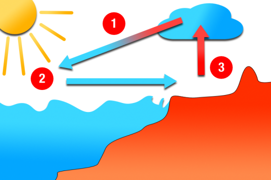
The day breeze in detail
- The orientation of the hill is important, the "best" configuration is a southwest facing hill
- Certain grounds are favorable such as a low coast, the presence of marshes (moisture)
- In the absence of synoptic wind, the daytime thermal breeze blows at 15/20 knots
- It extends out to sea over a distance of 10 to 15 minutes
- The vertical extension of the cumulus clouds will allow us to evaluate the strength of the thermal
And what happens at night?
At the end of the day, when the temperature gets cooler, the "pump" runs out of steam and so does the sea breeze. We feel less humidity and freshness of the air. The thermal wind disappears at first in the open sea before giving way to the synoptic wind. Then the temperature drops again and a less known phenomenon can appear, it is the night breeze.
The night breeze has exactly the same causes as the daytime thermal wind. That is, air masses with different temperatures trying to balance each other. But the effects on the water bodies are reversed.
At night, the sea keeps the temperature accumulated during the sunny hours quite well. On land, however, the surface cools down much faster. Thus, the cooled coastal air slips under the warm air from the open sea, which will create a call of air coming from the land to "replace" this air. This is the appearance of the night breeze.
The consequence is an onshore wind that we can exploit during the night to sail close to the coast. If the synoptic wind (the wind without local effects) is already coming from the land, it will reinforce this night breeze, and vice versa.
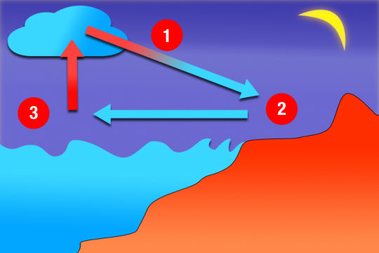
The night breeze in detail
- The night thermal wind will first establish itself on the coast then progress towards the open sea.
- It concerns a nautical band of about ten miles in our regions.
- The night breeze also turns to the right throughout the night and ends up parallel to the coast in the early morning.
- Night breezes are weaker than day breezes, in the order of 6 to 12 knots.
- This wind is particularly sensitive to relief - katabatic winds - it is also stronger in estuaries and accelerates in valleys.
What are the essential elements of a thermal break?
- Be in a barometric swamp situation, in spring or summer.
- A synoptic wind of less than 15 knots
- A temperature difference of 4 to 5° between land and sea to start the "pump".
- A weak cloudiness. The presence of stratiform clouds is a bad sign, while the presence of cumulus clouds is almost a sign of thermics
- Instability is needed to stir the different air masses to prime the pump.


