

Before attacking navigation in these waters, the tide directory should first be studied in detail. A cruise in Iroise can be programmed according to the time of day and the tidal coefficient! It is preferable to sail, for the first time, with low to medium amplitude tides, i.e. with tidal coefficients not exceeding 75. The tides generate strong currents which give rhythm to the navigation: they shorten the distances when they are favourable, but slow down strongly, or even prevent the progression in the opposite case.
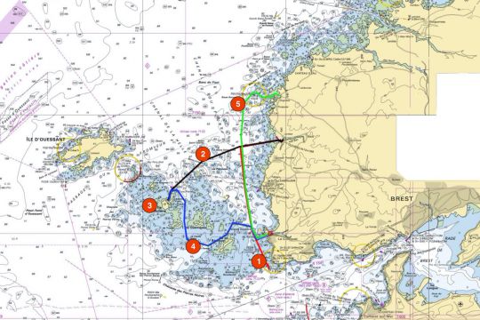

Day 1: Pointe Saint-Mathieu - Lanildut - 12 miles

Coming from Brest, Camaret-sur-Mer or the Raz de Sein, go to the Vieux Moines turret, at the foot of the Pointe Saint-Mathieu, to approach the Chenal du Four.

Old Monks' turret in front of Pointe Saint-Mathieu
Depending on your boat and taking into account the current, it is recommended that you arrive at Les Vieux Moines no later than two hours after low tide. Take Camaret or the Aber Ildut as a reference port. The tidal current is 350° and will therefore take us up without any problem. However, you must make sure you sail at a speed higher than the current so that your boat remains manoeuvrable. Sailing with little wind is not always ideal.
You have to go up to the lower St-Paul, materialized by a port channel buoy, passing by the famous Grande Vinotière turret. It is recommended to pass these buoys in accordance with the navigation rules, as this also allows you to shift in relation to the current.

Then you have to continue to climb up, overflowing the Forks Plateau until you cross the Lanildut harbour entrance alignment. Beware of the rising tidal current which continues to move northwards. To return to Lanildut on a rising tide, it is preferable to stay in the southern part of the access channel to the aber to avoid the rocks outcropping to the north of the aber.
The port of Lanidut - Aber-Ildut
Very sheltered and afloat, it has recently been refitted: 16 visitor buoys (embossing or dumbbells) are at your disposal as well as a 70m pontoon line Discover all the features of the port of Lanidut - Aber-Ildut .

Day 2: Lanildut - Ile de Molène - 10 miles

To get to Molène for the first time, it seems easier to go around the north. So we leave Lanildut 2 hours after the low tide to keep some of the rising tide current. We stay on the alignment of the channel with the same precautions linked to the rising current as when returning home. Direction the cardinal W "la Luronne" then the N turret of the Faix and the rock of the Helle.

The "rising" current will facilitate the overflow of the Plasterworks and will bring you quietly into the NW of the plateau de la Helle. From there you descend slowly towards the lighthouse of the "Trois Pierres" and then the lateral channel marks.

You have just made a crossing through the channels of the Four and the Helle, seeing the Kéréon lighthouse which marks the entrance to Le Fromveur and the island of Ouessant just behind. Not bad for a first and it's not over yet..
The port of Molène
If you stay in the outer harbour, buoys are available. Depending on your draught and the tides, you will stay afloat. If your boat runs aground, you can move forward to the two small moles and anchor to their right. Molène is a fantastic stopover in S to NW winds. In N, NE and E winds it is less comfortable. All you have to do is enjoy your stopover and taste the Molène sausage smoked with seaweed. Discover all the characteristics of the port of Molène .
Read Living on a desert island is possible in the Molène archipelago

Day 3 - Molène - Molène - 3 to 7 miles
Free day! Take advantage of this day in the Molène Archipelago to visit other islands.

Anchorage to be preferred according to the winds and the tide. Never forget to place your anchor on a sandy bottom, both for the safety of your anchorage and for the protection of the seabed. Landing on uninhabited islands is forbidden during the nesting period and regulated outside this period. Find out more on the site of the Parc naturel marin d'Iroise (www.parc-marin-iroise.fr or www.molene.fr)

Several anchorages are possible for a picnic or a short break in particular environments. From the southern hold of Ledenez de Molène, via Triélen, Quemenez (towards the hold), Litiri (very close to the beach) or Béniguet you will have the choice. Beware, Litiri is a private island so it is forbidden to walk there. Be vigilant, calculate your tides, check the nature of the bottom and always think about the current. It's worth a look. Seals and dolphins are often present. Let them come close to you, don't go towards them. That's the best way to get a good look at them.

Litiri


Day 4 - Molène - Le Conquet - 14 miles

The day's route consists of reaching Le Conquet while once again enjoying the Molène Archipelago. This itinerary can be done without any real difficulty by leaving 2 hours before the low tide in the port of Molène. On leaving the port, take a road south towards the Chimère pass in the direction of the Vieille Noire beacon.
The current is always present and it is thus necessary to remain vigilant not to be deported to Triélen or Quemenez. Watch out for a few well-identified rock heads on your maps such as the Roche de l'Etoile or the Roche Glissante.
You can go around the Old Black beacon, but be careful, as the rocky plateau it signals extends up to 300m SE and you have the sharp rock sounded at 0.1 just next to it.
Then road towards the island of Béniguet by leaving the archipelago by the pass of Grand Courleau by going up to the beacon of the same name before going down towards the Vinotière that you know well.
The entrance to the Conquet presents no difficulty. Just leave the She-wolf turret on the port side and admire the Kermorvan peninsula. Be careful, however, of fishing boats and boats connecting with the islands, which obviously have to be let through.
Carrying the Conquet
The outer harbour is strictly reserved for fishermen and for connections with the islands. Some visitor buoys are accessible in the N. part, but may, depending on the tides, be dry. If your boat runs aground, you can sink towards the inner harbour or further down the aber. You will spend a quiet moment among the shorebirds. Discover all the characteristics of the Conquet port.

Day 5 - Le Conquet - Argenton - 12 miles

We will take part of the channel of the Four, raze the Four lighthouse and return to Argenton. This destination will allow you to wait for the next tide to continue your cruise towards the country of Abers further north. Departure from Le Conquet at the beginning of the rising tide in order to benefit from a favourable current all the time of the navigation and to arrive in Argenton at high tide (or almost) and to choose your anchorage at the grounding well sheltered from the island Dolvez.

No particular difficulty for this almost full north direction. On leaving Le Conquet, it is best to go and fetch La Vinotière, an old friend now, and to go up towards the Saint-Paul beacon, at the foot of the Pointe du Corsen which houses the famous CROSS of the same name. Then direction la Valbelle which you can exceptionally leave to port while paying great attention to the plateau des Fourches. The weather conditions of the moment will dictate your choice.
Next point of vigilance, Les Liniou, to overflow largely in case of swell. Continue north to approach the Four lighthouse. If conditions allow, you can go around it (with precautions and vigilance) before heading towards the beacon of Le Bélier, the first lateral marker of the channel which leads you to Argenton. The entrance is spectacular and magnificent.
The port of Argenton
The entire harbour is stranded on hard sand without any significant rock heads. It is also possible to run aground along the wharf. In dead waters, if you stay north of the island of Dolvez, you can run aground on probes at +2m and stay dry for a shorter time Discover all the characteristics of the port of Argenton.
Article written with the precious complicity of Cabotage en Bretagne ( www.cabotage-en-bretagne.fr )
Map holdings from data.shom.fr Geodetic system: WGS84


