MOTHY (Modèle Océanique de Transport d'HYdrocarbures), the drift forecasting method in place at Météo France, was initially designed to predict the drift of fuel slicks in case of oil spills. It was after major disasters such as Exxon Valdez or Amoco Cadiz that the need for a reliable pollution monitoring model was created. Today this model is used all over the world for the recovery of shipwrecked vessels. It is notmanet which was followed for the recovery of Kevin Escoffier in the Vendée globe 2020-21.
A double calculation model
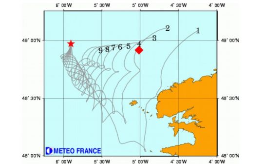
It is a model that is based on 2 layers:
- The "media" layer, or ocean model, developed to best represent the surface current. At all points of the globe, the currents present on different layers in which pollutants could be found are modeled. These files are created by exploiting satellite imagery, in-situ buoys and an extensive history of water depth, wave height and swell records.
- The MOTHY layer concerns slicks or floating objects. It assumes that an identified object (oil slick, container, plane, human...) has a typical drift profile, which will hardly vary. It will be subject to winds and currents, will float more or less and will be more or less degraded, but the displacement will remain linear in all cases.
Panel of 72 distinct targets
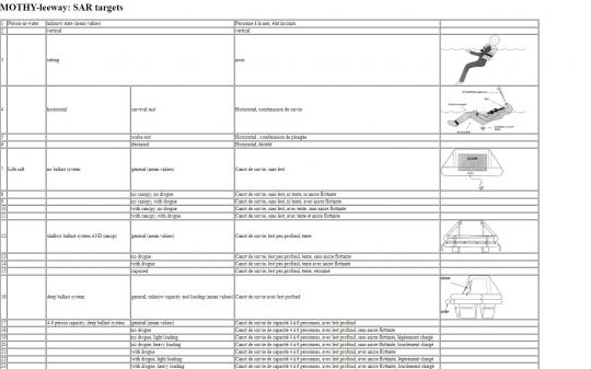
Thus, 72 targets have been created for the efficient operation of the model. They are extremely detailed, not being limited, for example, to a person, but differentiating between a clothed person and a dead person, or even differentiating between a USCG life-support chain and a weighted lifeboat.
These targets, called SAR Target These "standardised" data are used worldwide, allowing Météo France operators to respond accurately to any calculation request.
Thus, for example, as Race Director Jacques Caraës explains: " Météo France provided us with the MOTHY model to predict the location of Kevin's boat 2, 6, 9 and 12 hours after his distress beacon was triggered. This allowed us to optimize the dispatch of boats to the area and thus save precious time in the search. "
As you can see, Mothy is widely used today in SAR operations ( Search And Rescue ) for sea rescue.
This database currently contains 72 targets, but is constantly evolving with the addition of more than 5 new targets per year.
A fast calculation method
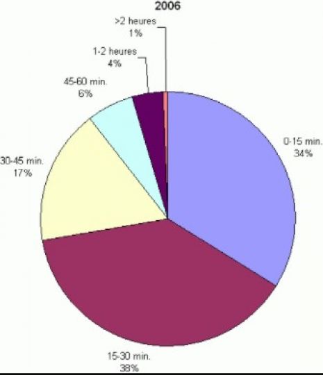
The power of Météo France's computers allows for a rapid response to requests. Thus, 72% of the calculation requests are served within the hour (time between the calculation request and the delivery of the results). 20% of the requests concern the location of people who have fallen overboard.
Since 1994, the year of creation of the drift forecasting service within Météo France, there are, except for major accidents (Air-France flight MH370, Erika ...), nearly 1000 activations that take place each year and to which the operators of the French Public Service respond 24 hours a day.
A model based on reality
The quality of the drift forecast depends directly on the quality of the wind forecast used. From this point of view, Météo-France uses a large number of meteorological data sources, including :
- AROME covers all the coasts of France, with a mesh of 1.3 km around the metropolitan coasts and 2.5 km on the areas of responsibility of the DOM/TOM.
- ARPEGE a global model with a variable mesh, centered on France, for forecasts over the European seas and the near Atlantic
- The model IFS the European Centre for Medium-Range Weather Forecasts (ECMWF) for overseas forecasts or for medium-range forecasts.
The MOTHY model integrates the currents analyzed and forecasted by operational oceanography systems such as MERCATOR and MFS. These systems calculate the main ocean variables ( temperature, salinity and current speed ). They use data from altimetry satellites ( sea level measurements ), and in-situ data such as sea surface temperature and vertical temperature and salinity profiles measured at sea. Finally, they integrate the data collected by each sailor, whether a yachtsman or a racing skipper, who agrees to transmit the information they collect during their navigation.
Permanent adjustment of the calculation models
The assimilation of measured data into ocean models is an essential component of operational ocean forecasting systems. It is the only way to regularly adjust the model results. Indeed, by definition stable, a mathematical model will always tend to deviate from reality. Fresh data provided by buoys and satellites make the simulated state of the ocean more realistic over time. Analyses and forecasts at 2 weeks are available every week.
Containers and people
A version of the model can predict the drift of floating objects such as containers. Real dangers for navigation, the containers fallen into the sea must be permanently signaled to the navigators or better, recovered so as not to constitute any more dangers. It is the moment of alert (as close as possible to the fall into the water) that will determine the accuracy of the calculation. The more precise the alert, the better the chances of recovering the lost object.
MOTHY-leeway, is now applied to 72 drifting targets such as people in the water, beach gear, life rafts or ships ( from sailboat to cargo ship ). The initial knowledge base of this algorithm was built by the US Coast Guard based on experiments at sea. It is naturally enriched by experimental results or feedback from organizations specialized in simulation in the first case, from rescue organization teams ( CROSS or MRCC ) in the latter case.
Key dates
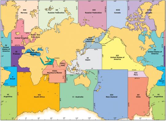
- january 1994: the S.I.U.P.M. is set up: Météo-France is responsible for zones II and III and is a support service for zones I, III, VII and VIII.
- february 1994: MOTHY can be activated by a marine forecaster 24 hours a day (for hydrocarbons only).
- june 1996: signature of the agreement with Cedre.
- march 1998: container version.
- december 1999: Erika accident.
- november 2000: accident of the Ievoli Sun.
- april 2002: the instruction of 4 March 2002 on the response to marine pollution (national POLMAR documentation), specifying the role of Météo-France, was published in the Official Journal.
- november 2002: Prestige accident.
- july 2007: MOTHY version 2.0 integrates currents from operational oceanography systems.
- february 2008 : MOTHY version 2.1.
- october 2008 : MOTHY version 2.2.
- september 2009: MOTHY version 3.0 integrates 63 SAR targets.
- March 2010 : MOTHY version 3.1
- october 2010: MOTHY version 3.2 integrates AROME.
- april 2011 : MOTHY version 3.3 integrates ALADIN overseas.
- september 2013: MOTHY version 4.0 integrates probabilistic forecasts and ocean multi-forcing.
- july 2015: MOTHY version 4.1 integrates 13 new targets.
- october 2015: MOTHY version 4.2 integrates a new target (poti marara).
- april 2016: MOTHY version 4.3 integrates the overseas AROME, MERCATOR global at 1/12° and MERCATOR IBI at 1/36°.
- june 2016: MOTHY version 4.4 integrates the change of tack.
- october 2017 : MOTHY version 4.4.1
- july 2018: MOTHY version 4.5 integrates MFS at 1/24°.
- march 2019: MOTHY version 4.6 integrates teledetected sargasso slicks.
- april 2019: MOTHY version 4.7 integrates slicks (oil, sargassum) of large geographical extent.
- june 2019: MOTHY version 4.8: improvement in the Mediterranean (MFS current) and in French Polynesia (Tuamotu Archipelago, Fakarava).
- january 2021: MOTHY version 4.9: improvement around the archipelago of Saint-Pierre-et-Miquelon and in French Polynesia (Tuamotu Archipelago, Rangiroa). Integration of the ShapeFile format. Optimization of KMZ and GPX formats. Update of the list of pollutants.
- february 2021: MOTHY version 4.9.1: 6 new targets added.


